Name
ST_MapAlgebraExpr — 2バンド版: 二つの入力バンドに対する妥当なPostgreSQL代数演算で形成された、指定したピクセルタイプとなる1バンドラスタを生成します。バンドを指定しない場合には、どちらも1番と仮定します。結果ラスタは、一つ目のラスタのアラインメント (スケール、スキュー、ピクセル角位置)にあわされます。範囲は"extenttype"引数で定義されます。取りうる"extenttype"の値はINTERSECTION, UNION, FIRST, SECONDです。
Synopsis
raster ST_MapAlgebraExpr(raster rast1, raster rast2, text expression, text pixeltype=same_as_rast1_band, text extenttype=INTERSECTION, text nodata1expr=NULL, text nodata2expr=NULL, double precision nodatanodataval=NULL);
raster ST_MapAlgebraExpr(raster rast1, integer band1, raster rast2, integer band2, text expression, text pixeltype=same_as_rast1_band, text extenttype=INTERSECTION, text nodata1expr=NULL, text nodata2expr=NULL, double precision nodatanodataval=NULL);
説明
![[Warning]](images/warning.png) | |
ST_MapAlgebraExpr は2.1.0で非推奨になりました。代わりにST_MapAlgebra を使います。 |
expressionで定義された妥当な二つのバンドへのPostgreSQL代数演算を入力ラスタ (rast1, rast2)に適用して、一つのバンドを持つラスタを生成します。nband1, nband2が指定されない場合には、1番バンドと仮定します。新しいラスタは、一つ目のラスタと同じアラインメント (スケール、スキュー、ピクセル隅)を持ちます。新しいラスタは、extenttype引数で定義される範囲になります。
- expression
二つのラスタとPostgreSQL定義済み関数/演算子を含むPostgreSQL代数式です。関数と演算子は、二つのピクセルがインタセクトするピクセルの値を定めます。たとえば(([rast1] + [rast2])/2.0)::integerといったふうになります。
- pixeltype
出力ラスタのピクセルタイプです。必ずST_BandPixelTypeに挙げられたものの一つになるか、省略されるか、NULLに設定されます。引数として渡されないかNULLが渡された場合には、一つ目のラスタのピクセルタイプになります。
- extenttype
新しいラスタの範囲を制御します。
INTERSECTION- 新しいラスタの範囲は二つのラスタのインタセクトした領域です。これがデフォルトです。UNION- 新しいラスタの範囲は二つのラスタの結合です。FIRST- 新しいラスタの範囲は一つ目のラスタと同じです。SECOND- 新しいラスタの範囲は二つ目のラスタと同じです。
- nodata1expr
rast1がNODATA値で、特にrast2ピクセルに値がある時に、rast2だけを返すか返すべき値を定義する定数を含む代数式です。- nodata2expr
rast2がNODATA値で、特にrast2ピクセルに値がある時に、rast1だけを返すか返すべき値を定義する定数を含む代数式です。- nodatanodataval
rast1とrast2のピクセルの両方がNOADTA値になる場合に返すべき定数です。
pixeltypeが渡された場合には、新しいラスタは、指定されたピクセルタイプのバンドを持ちます。pixeltypeとしてNULLが渡されたりピクセルタイプを指定しない場合には、新しいラスタはrast1と同じピクセルタイプになります。
数式の中で使える語は、元バンドのピクセル値を参照する [rast1.val], [rast2.val]、1始まりの列/行インデクスを参照する[rast1.x], [rast1.y]などです。
Availability: 2.0.0
例: 2バンドの共有と結合
元のラスタから1バンドラスタを生成します。元のラスタバンドの値について2で割った余りが入ります。
--Create a cool set of rasters --
DROP TABLE IF EXISTS fun_shapes;
CREATE TABLE fun_shapes(rid serial PRIMARY KEY, fun_name text, rast raster);

-- Insert some cool shapes around Boston in Massachusetts state plane meters --
INSERT INTO fun_shapes(fun_name, rast)
VALUES ('ref', ST_AsRaster(ST_MakeEnvelope(235229, 899970, 237229, 901930,26986),200,200,'8BUI',0,0));

INSERT INTO fun_shapes(fun_name,rast)
WITH ref(rast) AS (SELECT rast FROM fun_shapes WHERE fun_name = 'ref' )
SELECT 'area' AS fun_name, ST_AsRaster(ST_Buffer(ST_SetSRID(ST_Point(236229, 900930),26986), 1000),
                        ref.rast,'8BUI', 10, 0) As rast
FROM ref
UNION ALL
SELECT 'rand bubbles',
                        ST_AsRaster(
                        (SELECT ST_Collect(geom)
        FROM (SELECT ST_Buffer(ST_SetSRID(ST_Point(236229 + i*random()*100, 900930 + j*random()*100),26986), random()*20) As geom
                        FROM generate_series(1,10) As i, generate_series(1,10) As j
                        ) As foo ), ref.rast,'8BUI', 200, 0)
FROM ref;

--map them -
SELECT  ST_MapAlgebraExpr(
                area.rast, bub.rast, '[rast2.val]', '8BUI', 'INTERSECTION', '[rast2.val]', '[rast1.val]') As interrast,
                ST_MapAlgebraExpr(
                        area.rast, bub.rast, '[rast2.val]', '8BUI', 'UNION', '[rast2.val]', '[rast1.val]') As unionrast
FROM
  (SELECT rast FROM fun_shapes WHERE
 fun_name = 'area') As area
CROSS JOIN  (SELECT rast
FROM fun_shapes WHERE
 fun_name = 'rand bubbles') As bub
|
 インタセクションの場合
|
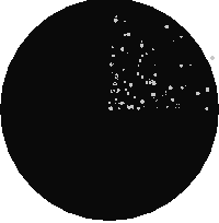 結合の場合
|
例: 別個のバンドとしてキャンバス上にラスタをオーバレイする
-- we use ST_AsPNG to render the image so all single band ones look grey --
WITH mygeoms
    AS ( SELECT 2 As bnum, ST_Buffer(ST_Point(1,5),10) As geom
            UNION ALL
            SELECT 3 AS bnum,
                ST_Buffer(ST_GeomFromText('LINESTRING(50 50,150 150,150 50)'), 10,'join=bevel') As geom
            UNION ALL
            SELECT 1 As bnum,
                ST_Buffer(ST_GeomFromText('LINESTRING(60 50,150 150,150 50)'), 5,'join=bevel') As geom
            ),
   -- define our canvas to be 1 to 1 pixel to geometry
   canvas
    AS (SELECT ST_AddBand(ST_MakeEmptyRaster(200,
        200,
        ST_XMin(e)::integer, ST_YMax(e)::integer, 1, -1, 0, 0) , '8BUI'::text,0) As rast
        FROM (SELECT ST_Extent(geom) As e,
                    Max(ST_SRID(geom)) As srid
                    from mygeoms
                    ) As foo
            ),
   rbands AS (SELECT ARRAY(SELECT ST_MapAlgebraExpr(canvas.rast, ST_AsRaster(m.geom, canvas.rast, '8BUI', 100),
                 '[rast2.val]', '8BUI', 'FIRST', '[rast2.val]', '[rast1.val]') As rast
                FROM mygeoms AS m CROSS JOIN canvas
                ORDER BY m.bnum) As rasts
                )
          SELECT rasts[1] As rast1 , rasts[2] As rast2, rasts[3] As rast3, ST_AddBand(
                    ST_AddBand(rasts[1],rasts[2]), rasts[3]) As final_rast
            FROM rbands;
|
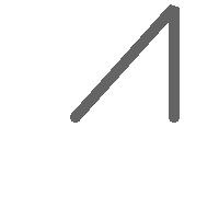 rast1
|
 rast2
|
|
 rast3
|
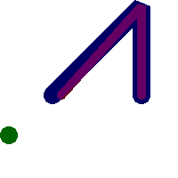 final_rast
|
例: 選択した区画の2メートル幅境界線を空中写真にオーバレイする
-- Create new 3 band raster composed of first 2 clipped bands, and overlay of 3rd band with our geometry
-- This query took 3.6 seconds on PostGIS windows 64-bit install
WITH pr AS
-- Note the order of operation: we clip all the rasters to dimensions of our region
(SELECT ST_Clip(rast,ST_Expand(geom,50) ) As rast, g.geom
        FROM aerials.o_2_boston AS r INNER JOIN
-- union our parcels of interest so they form a single geometry we can later intersect with
                (SELECT ST_Union(ST_Transform(the_geom,26986)) AS geom
                  FROM landparcels WHERE pid IN('0303890000', '0303900000')) As g
                ON ST_Intersects(rast::geometry, ST_Expand(g.geom,50))
),
-- we then union the raster shards together
-- ST_Union on raster is kinda of slow but much faster the smaller you can get the rasters
-- therefore we want to clip first and then union
prunion AS
(SELECT ST_AddBand(NULL, ARRAY[ST_Union(rast,1),ST_Union(rast,2),ST_Union(rast,3)] ) As clipped,geom
FROM pr
GROUP BY geom)
-- return our final raster which is the unioned shard with
-- with the overlay of our parcel boundaries
-- add first 2 bands, then mapalgebra of 3rd band + geometry
SELECT ST_AddBand(ST_Band(clipped,ARRAY[1,2])
        , ST_MapAlgebraExpr(ST_Band(clipped,3), ST_AsRaster(ST_Buffer(ST_Boundary(geom),2),clipped, '8BUI',250),
         '[rast2.val]', '8BUI', 'FIRST', '[rast2.val]', '[rast1.val]') ) As rast
FROM prunion;
|
 青線が対象区画の境界です
|